ChazzCreations Limited
© 1974-2026 ChazzCreations.com A Non~profit Organization. Over 50 years of Family Genealogy Research. Pictures may be used or copied with the hopes that it keeps the family history going to the next generation...
ChazzCreations
PO BOX 1909
POST FALLS, ID 83877
Lick Skillet ~ Adamsville
Joseph Shaw moved his family from SC to Lickskillet, GA, a part of Fannin County (near Atlanta, was later changed to Adamsville). Founded as a farming village, Adamasville was possibly named for early resident G. W. Adams, who farmed there in 1882 when it was called Lick Skillet. The name was changed to Adamsville in 1906. Joseph died during the Typhoid fever breakout, 1853. After Josephs death, the family moved a little north of Dalton, GA. There is a huge section called Red Clay, near Cohutta, GA, and a rail system ran through there. This is when the war between the states broke out and Gardiner Shaw left for the Georgia Regiment in 1861.
Early history of Lick Skillet
The early history of Lick Skillet and this area, was closely tied to the roads that led from ferries and bridges at the Chattahoochee River to downtown Atlanta. Originally called Lickskillet, this settlement is now known as Adamsville; the name was changed in about 1870, one year after the founding of the Adams Lodge a Masonic organization, organized by George W. Adams.


A winding dirt road of the 1860s which passed Ezra Ch. (S.E. cor. Mozley Park), & continued S.W. to Gordon Terrace, where it joined Gordon R. & ran westward to a cross-roads settlement called Lick Skillet, now known as Adamsville. The road, Mozley Drive, did not exist in 1864. Lick Skillet Road is cited frequently in reports, Confederate & Federal, as are 2 other landmarks of the battlefield: Ezra Church and Alms House. The latter stood near the present Gate House of the West View Cemetery. The Battle of Ezra Ch. began with the advance of S.D. Lee’s A.C. (deployed E. & W. of the Alms House), northward across Lick Skillet Road.

The lone headstone near the wood line marks the grave of a Confederate officer named Lt. Edward Clingman who died in the Battle of Ezra Church. There is a small section of Confederate earthworks in the woods behind the headstone. The grave is near the old Hornsby family cemetery in that part of Fulton County that was once Campbell, near the river. Some years after the War Between the States, relatives of Lt. Edward Peter Clingman erected a granite marker at the place and enclosed the spot with an iron fence. The marker reads: "Lieut. Edward Peter Clingman, C.S.A., son of Dr. and Mrs. Henry Patillo Clingman, of Goldsboro, N.C. Born Apr. 23, 1842, killed in battle near Atlanta, Ga., Apr. 23, 1864, while leading his Co. E, 3 Ark, Regt. Cavalry in a charge against the Federals. Entered the Army, Apr. 1861. "The eternal God is thy refuge and underneath are the everlasting arms. Deut. 38:27.

Westview Cemetery, a marker describes the Battle of Ezra Church. Putnam Darden’s Mississippi Battery was stationed near here on the hill behind the Alms House (poor house) that served as a battlefield landmark. This battery support Brown’s assault on the Federal lines near Battle Hill.

Mozley Park, the site of Ezra Church, name sake of the battle. The Federal lines came to this point and started to turn in a generally north eastern direction. Wangelin’s Brigade of Wood’s Division, 15th Corps(US) was positioned here at the church and extended just to the east. Williamson’s Brigade of the same Division was positioned at the church and extended just to the north east. They used the church pews and wood from the church to fortify their position and fend off the attacking Confederates of Clayton’s Division.


The original main entrance, now closed, to Westview Cemetery, sits on the site of what was once the Alms House (poor house). This was a known battlefield landmark and Brown’s Division of S.D. Lee’s Corps, formed their lines of battle in the area as they prepared to assault the right side of the Federal line.
It was not until the 1950’s and early 1960’s that major development reached West Atlanta. This growth is reflected in the number of new subdivisions, commercial outlets and schools. The initial phase of the Boulder Park subdivision was platted in 1951. It was not until 1958 that Carroll Heights, Fairlane Heights & other subdivisions were planned. Collier Heights Plaza was developed in Adamsville in the early 1960’s to accommodate the growing residential community. Schools were also constructed to serve the increased school age population. Towns Elementary (1935), Harper High School (1963), Miles Elementary and Adamsville Elementary are named for distinguished graduates of colleges in the Atlanta University Center Complex. George A. Towns (1870-1861) Charles Lincoln Harper (1877-1966) Leonora P. Miles (1872-1973) Interstates 20 and 285 were also constructed during the sixties. The main artery leading from Adamsville into downtown Atlanta is now known as Martin Luther King, Jr. Drive. Earlier names for the road were: Gordon, Garrett’s Bridge, Adamsville, Lickskillet and Howell’s Ferry.
Cohutta ~ Red Clay Area


Joseph Shaw died during the Typhoid fever breakout, 1853. After Josephs death, the family moved a little north of Dalton, GA. to Cohutta. The architecture of the small city gives the impression that it once displayed a vibrant little downtown; this is perhaps due to the once booming railroad system that still rumbles through Cohutta. Indeed, Cohutta reflects the trajectory of many smaller towns in the United States. The town emerged as a stop on the railroad from Cleveland, Tennessee to Dalton, Georgia, and served as the center for the surrounding farming areas. According to local lore, the town was originally known as "Shakerag," from the rag would-be passengers would wave to stop trains passing through. In the 1920s, the town had a bank and a hotel, as well a high school, and was frequented especially in summer by inhabitants of Chattanooga seeking cooler temperatures. The high school burned down in 1952, and was not rebuilt. As late as the late 1960s, Cohutta had a small supermarket, as well as three smaller "sundry" stores, a feed and seed, and the hair salon that is obligatory in practically in all small towns in America. The improvement of roads, and the ease of access to larger cities (in this case, Dalton), drew shoppers away, so that by the 1990s, Cohutta had no businesses at all.

Cohutta School, said to be the second school building built in Cohutta

Cohutta First Baptist Church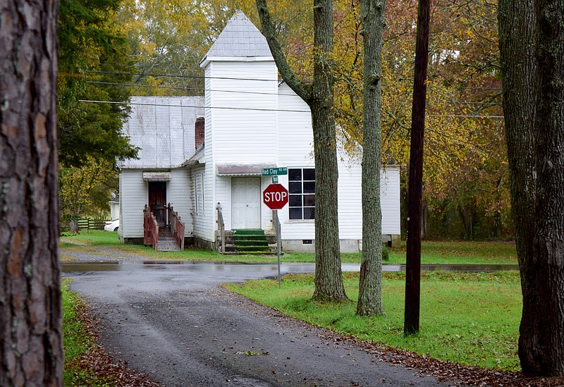


Cohutta is a town in Whitfield County, Georgia, United States. Over the last decade, the surrounding area has become something of a bedroom community for Dalton, with housing developments taking over many of the farms in the area. Whether the "gentrification" of the area will lead to a revival of Cohutta itself is problematic. Cohutta also prides itself on the Red Clay State Historic Park that serves as a national Native American meeting ground, Cherokee memorial with a museum, as well as an outdoor park and recreation center for visitors. This part of the state is extremely rich in Cherokee history as well as classic southern heritage that is complemented by the foliage of Georgia and Tennessee. Cohutta is a town in Whitfield County, Georgia, United States. Formed along the railroad, Cohutta is a city rich in land and agriculture. Visitors are welcome to enjoy the city's museum that celebrates Cohutta's history, enjoy a scenic drive along the Cohutta-Chattahoochee Scenic Byway, and explore nearby Red Clay, the last council grounds of the Eastern Band of Cherokee prior to the Trail of Tears. It is part of the Dalton Metropolitan Statistical Area. The population was 764 at the 2020 census.

Cohutta Mountain Wilderness in North Georgia
Deep in the mountains of North Georgia lies a rugged, untamed wilderness. Thundering waterfalls cascade over rocky cliffs into pools of crystal clear water. Forests filled with shady, moss-covered creek banks, fern, rhododendron and towering hardwoods stretch mile after never-ending mile. With more than 40,000 acres in Georgia and Tennessee (where its known as Big Frog Wilderness Area), the Cohuttas comprise the largest wilderness east of the Mississippi.The Cohutta Mountains are part of the oldest known mountains in the world. They run from Fannin County northeast to the Tennessee-North Carolina border, where they are known as the Smoky Mountains, and once bordered a prehistoric ocean. It is from these mountains that the Cohutta Wilderness Area gets its name. Within the Cohutta Mountains are peaks that rise to 4,200 feet and more than a hundred miles of hiking trails. Within the Wilderness Area itself are 13 trails that total more than 87 miles of unusual remote hiking. Other than on the popular Jacks River Trail, it is possible to hike in this area for days during the Spring and Fall and not see other backpackers. Two rivers (Conasauga and Jacks) flow through the Cohuttas, forming the major valleys on the east and west sides of the Wilderness Areas, is home to stunning waterfalls, clear, rushing streams and over 70 species of fish. In the river valleys the flora is prolific. It is not uncommon to see a wide array of plant life, thickly covering any land that gets available sunlight. As the trails climb the mountains the plants lessen, mostly because the trees block the sun.


Cohutta Mountain Wilderness Jack River Falls

ChazzCreations
PO BOX 1909
POST FALLS, ID 83877